


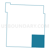
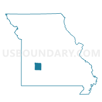
Mooney Voting District, Polk County, Missouri
About
Outline

Summary
| Unique Area Identifier | 609477 |
| Name | Mooney Voting District |
| County | Polk County |
| State | Missouri |
| Area (square miles) | 63.92 |
| Land Area (square miles) | 63.56 |
| Water Area (square miles) | 0.35 |
| % of Land Area | 99.45 |
| % of Water Area | 0.55 |
| Latitude of the Internal Point | 37.48335230 |
| Longtitude of the Internal Point | -93.24697430 |
Maps

Graphs
Select a template below for downloading or customizing gragh for Mooney Voting District, Polk County, Missouri


Neighbors
Neighoring Voting District (by Name) Neighboring Voting District on the Map
- 1st Franklin Voting District, Greene County, MO
- 1st Jackson Voting District, Greene County, MO
- 1st Robberson B Voting District, Greene County, MO
- East Looney Voting District, Polk County, MO
- Jackson Voting District, Dallas County, MO
- Sheridan Voting District, Dallas County, MO
- South Benton Voting District, Polk County, MO
- Southeast Marion Voting District, Polk County, MO
Top 10 Neighboring County Subdivision (by Population) Neighboring County Subdivision on the Map
- Southeast Marion township, Polk County, MO (3,542)
- Mooney township, Polk County, MO (3,252)
- Jackson No. 1 township, Greene County, MO (2,869)
- Jackson township, Dallas County, MO (2,207)
- East Looney township, Polk County, MO (1,609)
- Sheridan township, Dallas County, MO (1,530)
- Franklin No. 1 township, Greene County, MO (1,502)
- Robberson No. 1B township, Greene County, MO (1,289)
- South Benton township, Polk County, MO (1,058)
Top 10 Neighboring Place (by Population) Neighboring Place on the Map
Top 10 Neighboring Unified School District (by Population) Neighboring Unified School District on the Map
- Dallas County R-I School District, MO (12,874)
- Fair Grove R-10 School District, MO (5,671)
- Pleasant Hope R-VI School District, MO (4,888)
- Halfway R-III School District, MO (2,223)
Top 10 Neighboring State Legislative District Lower Chamber (by Population) Neighboring State Legislative District Lower Chamber on the Map
- State House District 139, MO (39,224)
- State House District 133, MO (37,830)
- State House District 126, MO (36,895)
- State House District 119, MO (36,209)
Top 10 Neighboring State Legislative District Upper Chamber (by Population) Neighboring State Legislative District Upper Chamber on the Map
Top 10 Neighboring 111th Congressional District (by Population) Neighboring 111th Congressional District on the Map
Top 10 Neighboring Census Tract (by Population) Neighboring Census Tract on the Map
- Census Tract 9603, Polk County, MO (8,438)
- Census Tract 46, Greene County, MO (7,124)
- Census Tract 4803, Dallas County, MO (6,855)
- Census Tract 52, Greene County, MO (6,722)
Top 10 Neighboring 5-Digit ZIP Code Tabulation Area (by Population) Neighboring 5-Digit ZIP Code Tabulation Area on the Map
- 65613, MO (17,396)
- 65622, MO (8,716)
- 65648, MO (5,614)
- 65663, MO (2,481)
- 65725, MO (2,459)
- 65617, MO (1,630)